Route 2
COASTAL SABKHA (TRUCIAL COAST)
source http://www.soton.ac.uk/~imw/sabkha.htm
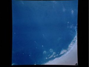
Satellite image of the trucial coast of the United Arab Emirates
An arid coastal flat subject to periodic or sporadic tidal inundation or storm surge is called a sabkha. Supratidal sabkhas form in protected environments:
A coastal sabkha is product of coastal offlap; beneath the surface of the sabkha is a wedge of intertidal and marine-shelf or lagoon sediments, capped with supratidal evaporitic crusts and a thin aeolian layer in some cases (McLane, 1995).
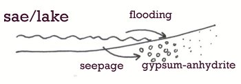 |
Diagram adapted from Tucker,(1991) |
A modern example of a coastal sabkha is the Trucial coast of the Arabian Gulf, an extremely arid region.
Arabian Gulf waters are only slightly more saline than normal sea water, but barrier islands along the coast create lagoons in which the salinity's are about twice normal.
The salt encrusted supratidal flats of the coastal sabkha on the margin of the Gulf are 8 to 10 km wide and grade landwards to wind swept continental sabkhas (McLane, 1995).
The water table is 1 to 2 m below the surface of the coastal sabkha. Sediment pore waters are largely derived from surface flooding of sea water. Pore water are as much as 10 times more saline than normal sea waters, brine temperatures average 34 C, sabkha surface temperatures may range upto a scorching 60 C.
Gypsum is being precipitated displacively within the sediments as:
From less than 1mm to more than 25cm in size.
Dolomitization of carbonate particles is commonly associated with gypsum precipitation, as a result of the high Mg/Ca ratio, and this releases calcium ions for further gypsum precipitation (Tucker, 1991).
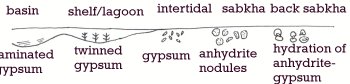 |
Diagram adapted from Tucker, (1991). |
This page was created by Pamela Williams
Last Modified:18/06/02